

Kirkjufell Mountain, the Most Photographed Spot in Iceland
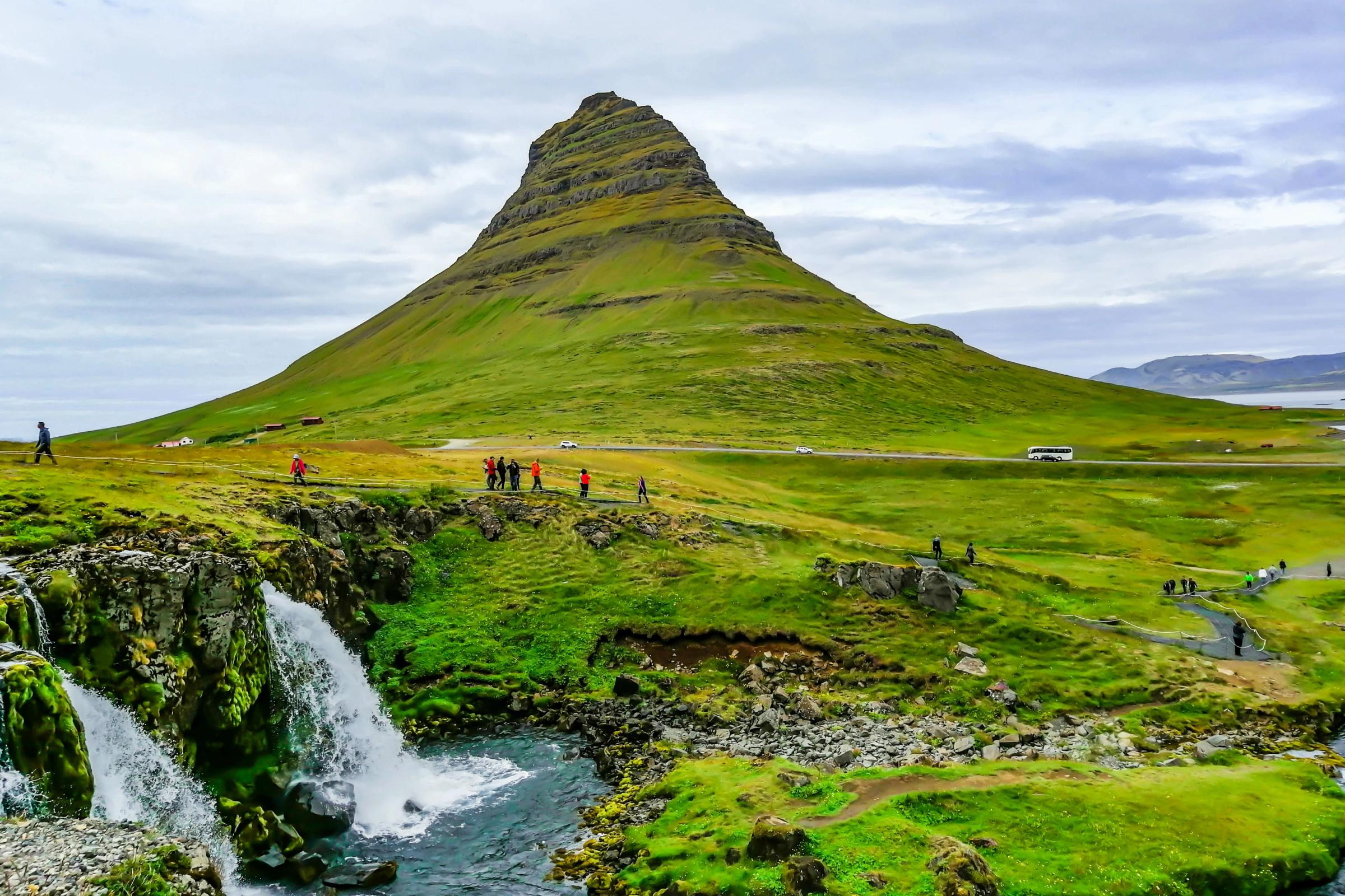
Kirkjufell is a mountain that catches the eye of everyone who visits Iceland. Sitting right by Kirkjufellsfoss waterfall, people have no trouble traveling far to see this incredible wonder, drawn by the Northern Lights, a chance to climb, or just to snap a picture.
Here’s what you need to know if you’re headed that way.
What’s Kirkjufell?
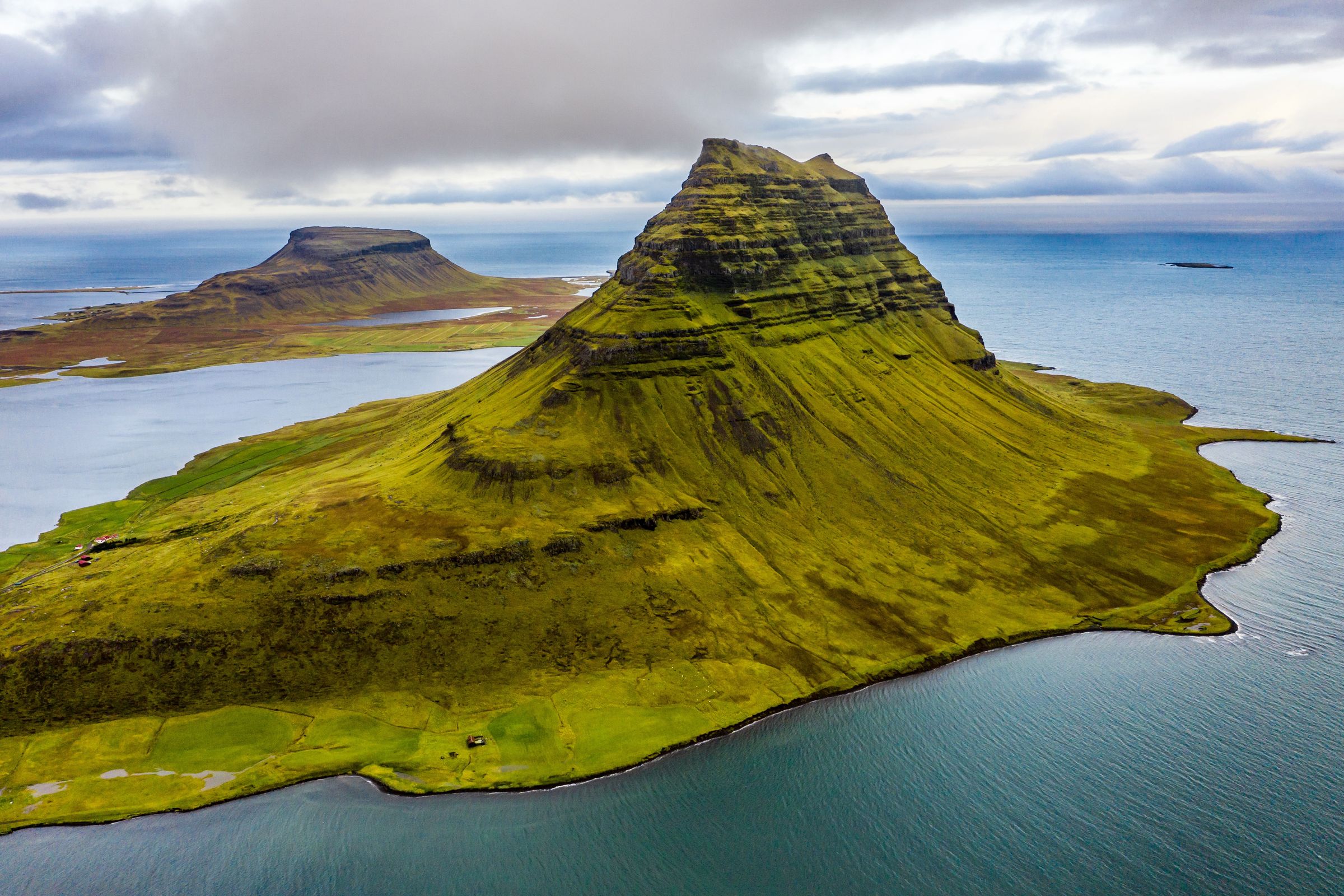
Kirkjufell is a mountain in Iceland, sitting on the Snæfellsnes Peninsula near a small town called Grundarfjörður. It’s about 180 kilometers from Reykjavik, a drive that takes around 2.5 hours and is 463 meters tall. People know it best as “Church Mountain” because it looks a bit like a church steeple, and it’s next to Kirkjufellsfoss, a beautiful waterfall that makes the place even prettier. It got famous from Game of Thrones as “Arrowhead Mountain,” but lots of folks come to take pictures or just see it for themselves.
Locals say it’s special—some think it’s a troll turned to stone at sunrise or a spot where elves hang out. Those might just be old tales, but it’s true Vikings used it to navigate because it’s so easy to see from the water. It’s been in poems too, not just Game of Thrones, and that’s part of why people like it so much.
The mountain is made of old rock from volcanoes and shaped by ice from a long time ago when glaciers covered most of the area. It’s what’s called a nunatak, and a survivor of the last Ice Age. It’s got some fossils hidden in it and is still changing a little because of melting ice up top. Whether you’re into the Northern Lights, a tough hike, or just a good photo, Kirkjufell has something to offer year-round.
Geological Wonders of Kirkjufell
Kirkjufell's rocks tell a story that goes back millions of years. When glaciers were everywhere, the rock stuck out above the ice, which is part of why it looks the way it does.
How It Was Made
A long time ago, lava from volcanoes built up the bottom of the mountain. That’s the dark, hard stuff you see at the base, from maybe 5 to 10 million years back. Later, more lava and some sandy rock piled on top, from about 700,000 years ago. The very top has a layer of stuff made from volcano ash. Then glaciers came and scraped it into the sharp shape it has now, leaving the peak poking out while everything else got worn down.
Old Bones and Clues
In the middle layers, there are fossils—bits of fish, birds, and shellfish from when Iceland was warmer, millions of years ago. Someone even found a whale bone once, which makes you think about what swam around here back then. There’s also a shiny, brownish rock mixed in, made when lava hit ice. It’s cool to look at, though most people walk right by it.
It’s Still Changing
The mountain isn’t frozen in time. The ice from the top is melting slowly, and that’s shifting things a little—researchers have been watching it for years. A few years back, a small slide on the west side uncovered some black, glassy rock nobody expected. It’s like Kirkjufell’s still telling us new things about itself.

Where is Kirkjufell & How to Get There
Kirkjufell sits on the Snæfellsnes Peninsula, a region in West Iceland also known as “Iceland in miniature.” It’s near a small town called Grundarfjörður, along the north coast by the water. The mountain’s easy to spot because it stands alone, with the Kirkjufellsfoss waterfall just a short walk away. It’s about halfway up Iceland’s west edge, surrounded by flat land, sea, and a few other hills.
Your best option is to rent a car. It gives you total flexibility and allows you to easily visit the many other attractions on the Snæfellsnes Peninsula.
From Reykjavik
Reykjavik, the capital, is about 180 kilometers away—roughly a 2.5-hour drive. You start by heading north on the Ring Road (Route 1). After about an hour, you turn left onto Road 54 at a town called Borgarnes. That takes you west across the peninsula, past fields and small towns, until you hit Grundarfjörður. The roads are paved, and there’s a gas station in Borgarnes if you need it. Once you’re in town, Kirkjufell’s right there—you can’t miss it. Parking’s by the waterfall, just off the road.
From Akureyri
Akureyri, up in the north, is farther—around 375 kilometers, so it’s about a 5-hour drive. You take Route 1 south from Akureyri, going through some hilly spots and past a couple of fjords. It’s a straight journey for a few hours until you reach a junction near a town called Blönduós. There, you turn right onto Road 54, heading west. That road winds through the peninsula, and you’ll pass a few farms and maybe some sheep before getting to Grundarfjörður. It’s all paved, but there’s not much to stop, so fill up in Akureyri.
A Couple More Options
If driving’s not your thing, you can take a bus from Reykjavik to Grundarfjörður. It’s run by a company called Strætó, leaves a few times a day, and takes about 3.5 hours. From Akureyri, it’s trickier, as there’s no direct bus. Tours from Reykjavik are another option; they pick you up, drive you out, and show you around, usually in a day. Either way, once you’re in Grundarfjörður, Kirkjufell’s a short walk from the main street.

When to Visit Kirkjufell
Kirkjufell looks and feels different depending on when you go. Each season has its own vibe, so it’s about what you’re looking for—quiet, a hike, or something to see.
Winter (November to March)
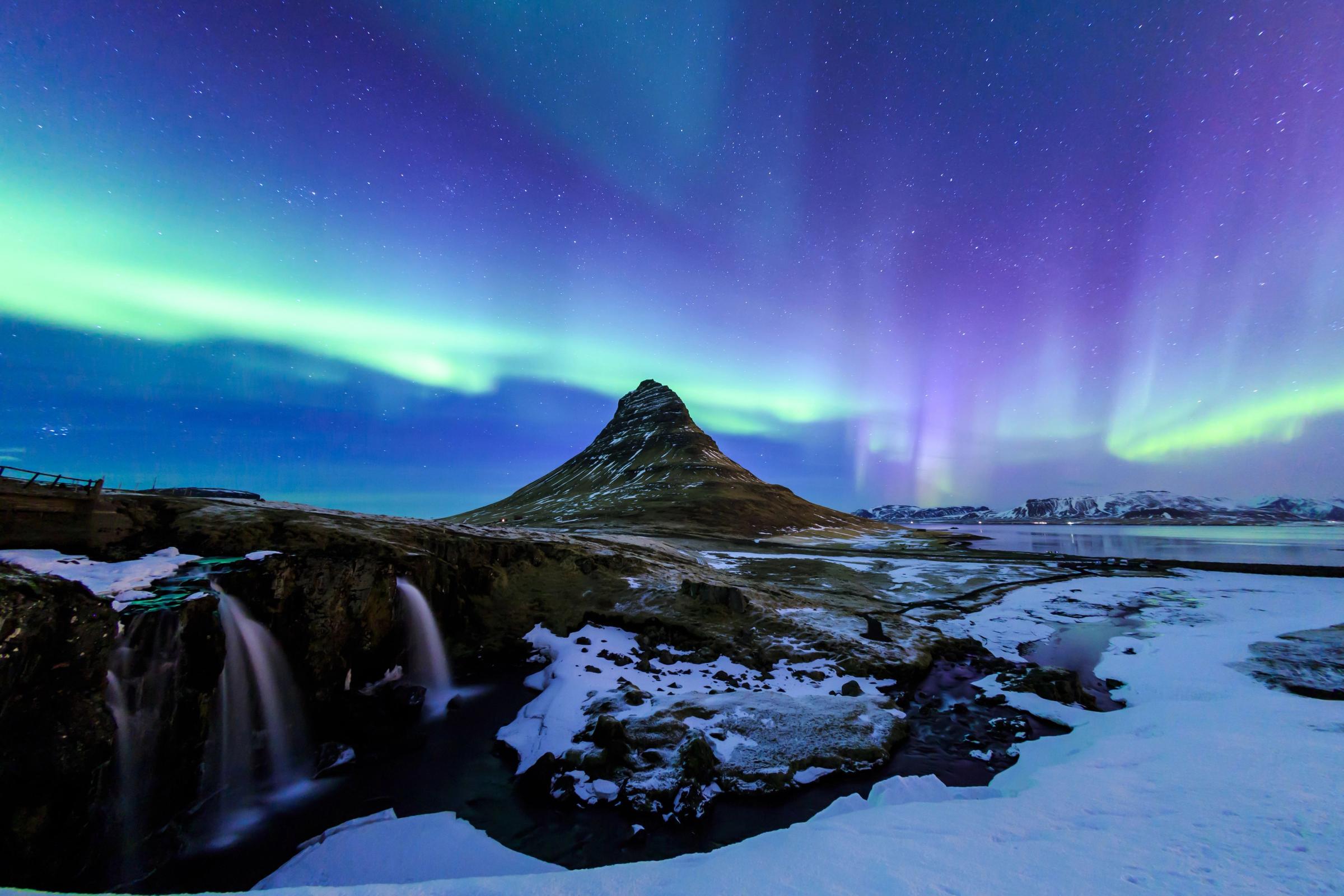
Winter, from November to March, covers the mountain in snow, it’s the best moment to see the Northern Lights. Days are short and there’s not much light pollution around. The roads get icy and it’s windy, so climbing’s off the table because it’s too risky. January and February are the best months to see the lights, and sometimes they reflect on the frozen water nearby, which we call the “Kirkjufell glow.” You can also join fishermen in Grundarfjörður to catch herring or cod, a real winter thing around here.
Spring (April to May)
Spring, from April to May, is when the snow melts and the waterfall gets loud, with days stretching to 16 hours by May and animals returning to the island. The trails turn muddy, and the weather changes fast from sunny to rainy, so getting there is not always easy. Puffins show up in April on cliffs nearby, and you can watch them flop around with binoculars. Melting snow makes little pools at the bottom that mirror the mountain, but they don’t last long. Bring waterproof shoes and a hot drink—it’s still chilly, but not many people visit.
Summer (June to August)
Summer, from June to August, has light almost all day—20 hours or more—and it’s warm enough, around 10 to 15°C. It’s the best time to hike the mountain. It’s the busiest time of the year, so the parking’s tight. You can climb with a guide, taking three hours total, and see the ocean and another big mountain from the top. At 2 a.m., it’s quiet with the sun still up low, a calm time to sit and look. If you want to get there before the crowds arrive, staying in Grundarfjörður the night before is a good idea.
Fall (September to October)
Fall, from September to October, brings fewer visitors, cool air, and the start of the Northern Lights, with grass turning yellow and a bit of snow on top. Rain makes trails slippery, days shrink to 10 hours by October, and climbing becomes tougher again as the ice comes back. Seals hang out on rocks in September, and kayaking from town gets you close to them. Around September 22 or 23, the sun lines up straight with the mountain–a unique sight. Go during the week and bring a jacket for the wind.


Capturing the Perfect Shot: Photographing Kirkjufell and Kirkjufellsfoss
Kirkjufell and Kirkjufellsfoss are great places to take pictures, with big, open views that let you get creative. Two spots work best: one’s right by the waterfall, where you can line up the mountain behind it, and the other’s across the road, where a small lake sits in front. The trick is timing—early morning or late afternoon, when the light’s soft and warm, makes the colors pop. You’ll see the rocks and water stand out better then, and it’s easier to get a shot you’d want to keep.
Reflections and Mirror Images
If you want pictures with reflections, head to the waterfall side of the road or look for puddles and little pools nearby after it rains. The water can mirror the mountain perfectly if you set up right. Use a lens that fits a lot in the frame, stand so the reflection sits dead center, and play with your camera settings a bit—make sure the light’s even so the mirror image comes out clear. It’s a simple way to get something that looks pretty cool.

Hiking and Climbing Kirkjufell
Going up Kirkjufell isn’t easy. It’s an arduous climb to the top, which is 463 meters high, and takes about three hours to go up and back. The path is steep and can be slippery, with loose rocks and some big drops. People have gotten hurt or worse trying it, so you must be ready.
It’s not a walk for just anyone—it’s not for experts, but not for beginners either. The ground’s tricky, and it can get dangerous if you’re not careful. I’d recommend going in the summer when it’s less wet, and having someone who knows the way helps a lot. Stick to the marked path—they’ve got ropes in spots to hold onto—and wear good shoes that grip.
Witnessing the Northern Lights at Kirkjufell
There’s not much light around Kirkjufell, so the Northern Lights show up bright and clear when they come. The best time to see them is between September and April, with March and September being the top picks because the nights are dark but the weather’s not as rough. You might catch green or purple streaks moving across the sky, and with the mountain sitting there below, it’s a view that sticks with you.
Five Places to Visit Near Kirkjufell
There’s more to see around Kirkjufell than just the mountain and waterfall. Here are five spots nearby worth a stop if you’re in the area.
Grundarfjörður
This little fishing town is right next to Kirkjufell, just a couple minutes away. It’s got a quiet harbor, a few places to eat, and a good view of the mountain from almost anywhere. It’s an easy place to hang out or grab a coffee.

Snæfellsjökull National Park
About 30 kilometers southwest, this park has an enormous glacier sitting on a volcano. You can drive up close, walk around, or look at it from the road. It’s a nice mix of snow and rocky land.

Djúpalónssandur Beach
A 40-kilometer drive west takes you to this black sand beach. It’s got old shipwreck pieces scattered around and smooth pebbles to walk on. The cliffs nearby make it feel a remote place.

Stykkishólmur
Head 40 kilometers east, and you’ll hit this colorful town. It’s got a small harbor, some old buildings, and a ferry if you want to cross the bay. It’s a laid-back stop with a bit of charm.

Arnarstapi
Roughly 50 kilometers southwest, Arnarstapi is a fishing village with cliffs and rock formations right by the sea. There’s a short path along the coast with lovely views, and you might spot some birds. It’s a simple place to stretch your legs.

Final Thoughts
Kirkjufell’s a place with a lot going on—old stories, rocks that tell you about the past, and a look that changes every few months. It’s more than just a quick stop. You can find something new if you take your time, whether it’s a hike, a photo, or just standing there listening. Pick when you go based on what you like, and you’ll get why it's so famous.
Frequently Asked Questions about Kirkjufell


