
Múlagljúfur Canyon: A Secret in South Iceland Waiting to Be Explored
Jump to chapter
Iceland is a country packed with amazing natural monuments. They can be found in every corner of the country, but certain regions are especially full of these wonders. And, without a doubt, South Iceland has a lot to see and do. Many of the most famous national landmarks are located in this part of the Island, and some are well-known worldwide. However, there are still a few places that not many people, apart from the locals, know and that don’t usually appear on travel guides.
If you’re looking for one, then you’re in luck. Múlagljúfur Canyon sits here, a stunning escape for travelers ready to explore beyond the usual stops. This rugged gorge, with its waterfalls crashing down mossy cliffs, showcases the rawest side of Iceland like few others. Away from the busy tourist trails, it offers crisp air, dramatic views, and a peaceful vibe that’s hard to resist. If you’re up for a hike and eager to uncover a lesser-known gem, Múlagljúfur is calling your name.
Key Takeaways
- Múlagljúfur is a deep and narrow canyon located in South Iceland.
- Hangandifoss, one of Iceland’s tallest waterfalls, is inside the canyon.
- There are several trails to explore the area, and it’s a prime hiking destination.
What’s Múlagljúfur Canyon?
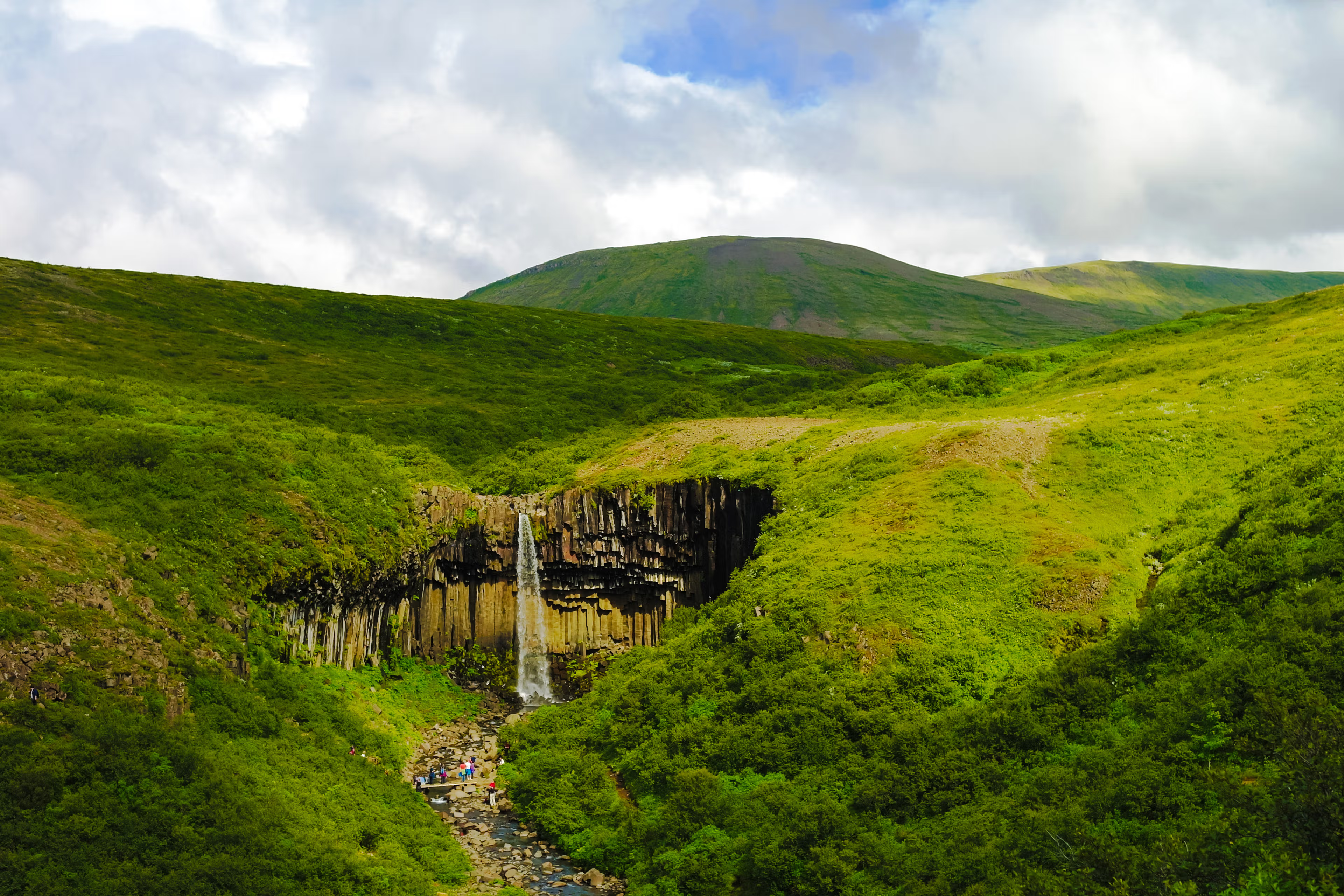
Múlagljúfur is a striking natural canyon carved into Iceland’s landscape. It’s located in the south of the country, just a stone’s throw from the famous Ring Road. It has a length of approximately 2 kilometers (1.2 miles) and, in certain places, it’s 400 meters deep (1,312 feet). It’s a fantastic example of the role that glacial waters have played in sculpting the country. The canyon’s walls are quite steep and covered in green moss that contrasts sharply with the dark volcanic rock beneath, giving it an astonishing look. Once you start getting closer, you’ll hear the sound of the water growing louder, as there are two breathtaking waterfalls inside the canyon: Hangandifoss and Múlafoss.
Hangandifoss is one of Iceland’s tallest waterfalls at 123 meters (403 feet). It cascades down from the canyon's edge into the bottom. The spray from the water catches the light if the sun is out, creating a colorful rainbow effect. A bit further down, Múlafoss hides deeper within the canyon. It’s considerably smaller but very beautiful, adding a different view to the already amazing setting. There’s a trail that connects these two natural monuments. It’s a bit narrow and has stones and overgrown bushes, so it can be a little bit tricky to walk through it.
There’s a viewing point that allows you to see almost everything together. The steep cliffs frame the waterfalls and, to the west, the powerful shape of the Vatnajökull glacier. Here you can soak in pure raw natural beauty, away from civilization, with only the water as a soundtrack.
From a geological perspective, Múlagljúfur is a product of the interaction between two of the primary forces that have shaped Iceland. Volcanic eruptions and glacial floods are responsible for the rugged walls and the deep valley inside the canyon.

Why Is Múlagljúfur Canyon Worth a Visit?
The astonishing looks of Múlagljúfur Canyon is enough to justify the trip there. Its raw, unspoiled beauty is a rare find in a country where many natural wonders have become tourist hotspots. On the other hand, Múlagljúfur is far from paved paths and tour buses- This canyon is still wild and free from commercial traps. There are no signs, no fences, just a trail that has been opened by the steps of those who know of this place. That creates a sense of discovery that feels very personal, as if you were one of the first to have trodden this place. Like if you were the first to discover a secret place.
Hiking is the main draw here, with trails ranging from moderate walks to the first viewpoint, which is about 45 minutes from the parking area, to longer treks like the one up to Múlafoss, the smaller of the waterfalls and the farther away from the parking area, which is around 2.5-3 hours round trip. If you are into photography, you’ll find endless inspiration here thanks to the canyon’s different textures and points of view. If not, you can simply soak in the sense of being in the middle of something untouched by human action.
Regardless of what you’re looking for, the payoff for coming up here is huge. You’ll get jaw-dropping views of the two waterfalls framed by the steep cliffs covered in moss, the chance to see the distant Vatnajökull glacier, and a peaceful escape from the crowds. The hike through the area is not an easy one, but almost everyone can handle it. It’s uneven and, at certain points, the bushes cover the path, but it’s easy to deal with. It’s not a path created by a machine, but opened by the steps of the different adventurers that, one after the other, have come to discover this hidden wonder.

Where’s Múlagljúfur Canyon and How to Get There?
As we have already mentioned, Múlagljúfur Canyon is in Southeast Iceland, in the southern edge of the Vatnajökull glacier. Even though it’s far from the usual tourists’ routes and not many people know of its existence, it’s surprisingly close to the Ring Road, or Route 1, Iceland’s main road.
It’s about 372 kilometers (231 miles) from Reykjavík, or a drive of roughly 4.5 hours if you go straight through. That might sound a bit too much for a day trip, but on your way, you’ll pass by iconic stops such as Seljalandsfoss and Skógafoss waterfalls, so you can make stops and add them as a stop on a larger itinerary.
Starting from the capital, take Route 1 heading east. Continue on it for quite some time. A few kilometers after you’ve passed the small town of Fagurhólsmýri, keep an eye out for an unmarked gravel road on the left just before Fjallsárlón lagoon, about 14 minutes (6.5 km) west of Jökulsárlón Glacier Lagoon. As there are no signs on the road, look for Múlagljúfur Canyon on Google Maps or another similar app, or the coordinates 63.9886667, -16.3971589 if you’re using a GPS.
From there, there’s a 2-kilometer (1.24 miles) gravel road that leads to an unpaved parking area at the canyon’s base. A 4x4 vehicle is strongly recommended, especially after rain when the road can become slippery or muddy; however, a sturdy 2WD can manage in dry conditions. The weather can have a huge impact on the roads, and they may even close if the weather is too harsh, especially in winter. Always check the road conditions before setting out.
The trail begins right in the parking area. Please note that there are no facilities available there. No shops, bars, or even toilets, just a rocky path going uphill. The trail is unmarked, but it’s straightforward and easy to follow. If you complete it, it’s 5 kilometers long (3 miles) round-trip. If you want to make it shorter, the round trip to the closest viewpoint is 2.5 kilometers (1.5 miles).


The Weather at Múlagljúfur Canyon
The weather in the canyon varies significantly from season to season.
Spring (April and May)
Spring comes with milder temperatures after the long and hard winter, averaging 0-5°C (32-41°F), but the canyon can still be muddy or snowy from the previous season. As the weeks pass by, the days lengthen, giving more time to explore, but rain and wind are common. The south of the country is not as cold as the center or the north, but is usually wetter.
Summer (June to August)
This is peak season, with temperatures between 8-13°C (46-55°F) and up to 20 hours of daylight by the end of June. The weather is more stable, usually sunny spells with occasional showers. The moss that covers the cliffs looks especially radiant, and the trails and roads usually are dry, so you’ll probably encounter some other explorers in the canyon.
Autumn (September and October)
The conditions are not very different from spring, but going in the opposite direction. The temperatures drop to 3-8°C (37-46°F), with shorter days and frequent rain or fog. The latter creates a beautiful atmosphere, but it can significantly lower visibility. The color of the moss turns to a golden hue, and the trails can be slippery, so it’s important to proceed with caution.
Winter (November to March)
Winters can be challenging at Múlagljúfur Canyon, with temperatures ranging from -5 to 3°C (23-37°F), often accompanied by snow or ice that cloaks the canyon. The gravel road would probably be impassable without a 4x4 car, and the trails can be tricky to walk on. Daylight shrinks to 4-5 hours, but the stark beauty of a frozen landscape can be magical if you're well-prepared.

What to Wear at Múlagljúfur Canyon
Iceland's weather is unpredictable, so packing smart is key to being prepeared for anything it throws at you.
- Sturdy Hiking Boots: Waterproof and grippy soles are essential, as the trails can be muddy or slippery. They are also quite uneven, so a good grip to the ankle is necessary.
- Casual shoes: Not for the hike, but if your shoes get wet or muddy, they come in handy for the trip back to your accommodation.
- Layered Clothing: Start with a moisture-wicking base layer, add a fleece or wool sweater, and top with a windproof, waterproof jacket.
- Warm Hat and Gloves: Even in the warmer months, winds can bite, especially at the canyon’s edge.
- Hiking Pants: Quick-dry or waterproof pants can help you cope with wet grass and potential rain.
- Socks: Wool or synthetic socks keep feet warm and dry—bring an extra pair just in case.
- Sunglasses: Even in the colder seasons, the sun reflected on the glacier or snow can be quite harmful.
- Backpack: Pack water, snacks, a first-aid kit, and a camera.

What to See and Do Near Múlagljúfur Canyon
The canyon's location is one of the best on the island if you want to make the most of your day, with tons of cool sights super close.
Skaftafell
This nature reserve was once a national park on its own, but was later integrated into the larger Vatnajökull National Park. It’s worth a visit for its diversity: you’ll find rare forests amid Iceland’s stark landscapes, and also opportunities to explore glacial tongues up close. There’s an extensive network of trails that go to all parts of the reserve. The visitor center offers maps and insights.

Svartifoss
This waterfall, one of the most famous in Iceland, is inside Skaftafell, but serves its own section. Svartifoss means “black waterfall” and it’s a 20-meter (65 feet) tall cascade framed by hexagonal basalt columns formed by ancient lava flows. The trail leading up to the waterfall is very beautiful, winding through birch woods and open slopes, and it’s easy to complete. The waterfall served as inspiration for Hallgrímskirkja, the biggest church in Iceland and arguably the most iconic building in Reykjavik.
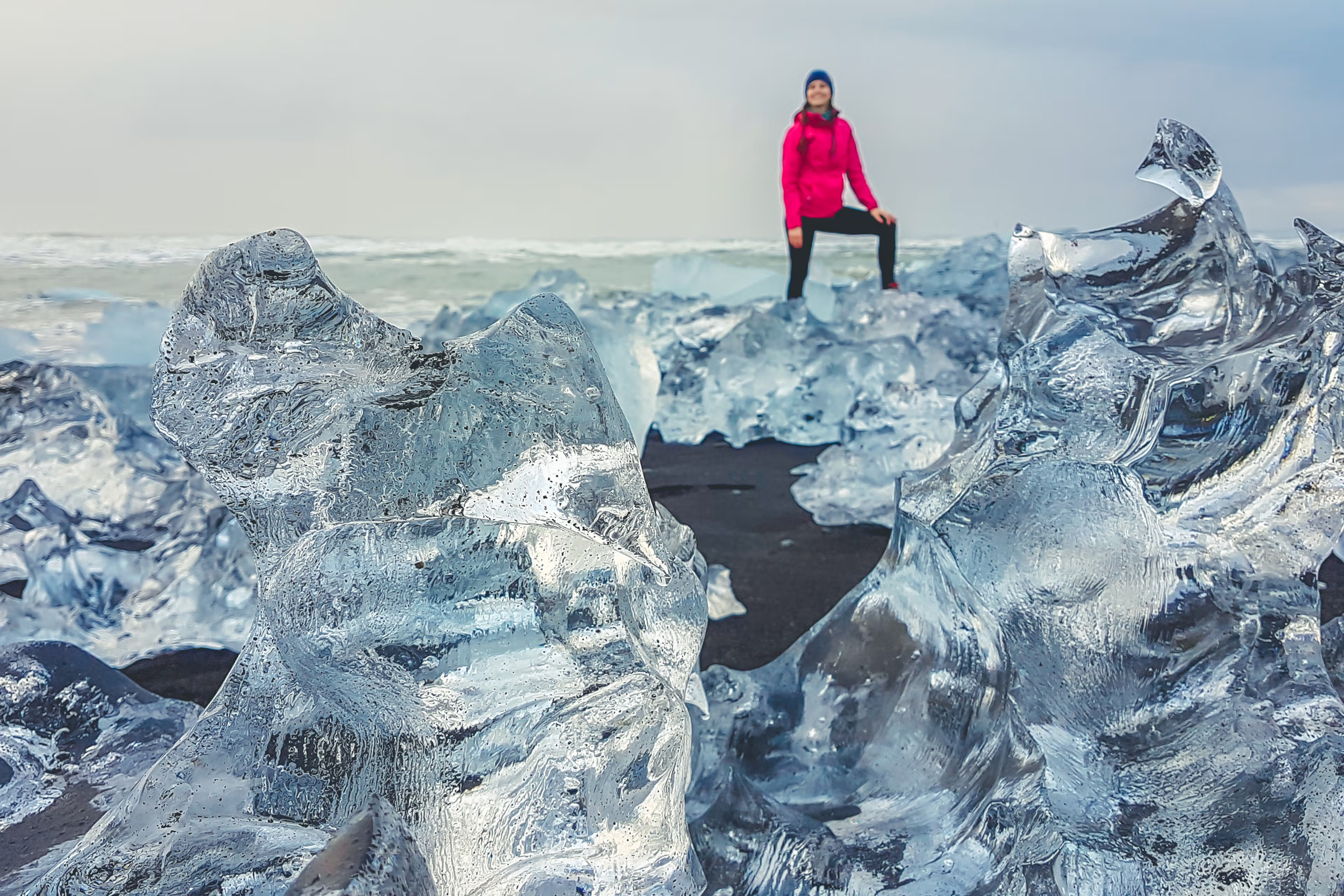
Jökulsárlón Glacier Lagoon
This iconic place is a mesmerizing blend of ice and sea. Jökulsárlón Glacier Lagoon is famous for the big pieces of ice that float on the water. These little icebergs have separated from the Vatnajökull glacier and stay on the lagoon’s surface before drifting out to the Atlantic Ocean. Some of them end up in the nearby Diamond Beach, where they create a shiny contrast between the blue ice and the black sand, hence the name of the beach.

Fjallsárlón
A quieter and smaller cousin to Jökulsárlón, this lagoon is really close to Múlagljúfur Canyon. Icebergs float in calm waters with the imposing presence of Vatnajökull glacier in the back. It’s a more intimate approach to glacial beauty, often free from crowds.

Vatnajökull National Park
Vatnajökull National Park, the largest national park in Europe, is full of natural wonders. The king of the park is the glacier of the same name, also the largest in the continent. Apart from it, you’ll find volcanic peaks, hidden ice caves, and trails that reveal the island’s raw power. The ice caves can only be visited in winter, while summer opens up hiking routes.

Eldhraun Lava Field
This expansive field of moss-covered lava is the most beautifully looking remains of the 1783-1784 Laki eruption, one of history’s most devastating volcanic events. The rugged volcanic rocks are covered by a thick blanket of green moss, creating a landscape that seems like another planet. There are trails to explore the field, but be very careful, as stepping on the moss is forbidden and could create damage that takes decades to recover.

Travel Tips
- Rent a 4x4: The gravel road to Múlagljúfur can be rough and difficult, especially in wet conditions. Select a vehicle with good clearance and verify the rental insurance coverage for gravel damage.
- Check Weather Daily: The weather changes a lot, so check the local forecast every day. Fog or high winds can obscure views and make trails tricky.
- Bring a GPS: The cell phone signal can be low or nonexistent. Also, there are no signs that mark the turnoff, so save the coordinates (63.9886667, -16.3971589) or use offline maps.
- Water and snacks: There are no facilities at the canyon. Bring everything you may need for the excursion, like snacks and water.
- Respect Nature: Stick to the trail to protect the fragile moss, and take all trash with you to keep the canyon clean.
- Start Early: Beat the potential crowds and enjoy the soft morning or late evening light for photos, especially in the summer.
- Watch Your Step: There are no fences and there can be loose rocks on the trail, so walk carefully. Don’t get close to the edge of the cliff.
Conclusion
Sometimes, spending a couple of hours in a place can create a memory for a lifetime. Without a doubt, Múlagljúfur Canyon is one of those. The south of Iceland is a region full of magnificent places, some of them famous all over the world. But some others are just as spectacular, but not many travelers have heard of them. Add this awesome place to your itinerary and you’ll discover something that will leave you speechless.
Related Blog Posts
 Canyons
Canyon Wonders: Natural Beauty in Iceland
Prepare to embark on a journey through the majestic canyons in Iceland, where glacial rivers carve breathtaking landscapes, and stunning geological features await curious adventurers. In this exploration, you’ll uncover the hidden gems and awe-inspiring beauty that make canyons in iceland an unforgettable experience for millions of visitors each year.
 Canyons
Fjaðrárgljúfur Canyon, a marvel carved in stone
Iceland is a land of incredible geographical and geological variety. The different kinds of landscapes here are amazing, and nature seems to have gone a little bit crazy in creating some of the most breathtaking places on Earth. Some have gained international fame, but others are not so well-known to visitors. One of them is the astonishing Fjaðrárgljúfur Canyon in the south of the country. This place, carved out by a winding river, has dramatic cliffs and rocks covered by a beautiful layer of green moss. Whether you are an adventurer seeking new trails, a photography lover, a nature enthusiast, or just a person who loves seeing amazing places, Fjaðrárgljúfur should be on your Iceland travel list.
 Canyons
Stuðlagil Canyon: A Natural Wonder in Iceland
Imagine standing in a beautiful canyon, surrounded by towering basalt columns, with a powerful glacial river flowing at your feet. Welcome to Studlagil Canyon, an otherworldly wonder hidden in eastern Iceland! In this blog post, we’ll unveil everything you need to know about visiting this unique destination, from its fascinating geological formation to hiking trails, viewpoints, and nearby attractions. Prepare to be captivated by the awe-inspiring beauty of Studlagil Canyon!
