

Iceland's F-Roads: Your Complete Guide to Highland Mountain Routes
Iceland's best landscapes sit beyond the paved Ring Road, hidden away in the rough Interior Highlands that you can only reach by F-roads. These mountain routes aren't your typical Sunday drive; they're unpaved gravel tracks that cross rivers, climb volcanic passes, and cut through some of the most remote terrain in Europe.
F-roads take you to places most travelers never see: the colorful rhyolite mountains of Landmannalaugar, the moon-like landscapes around Askja caldera, and the huge black sand deserts of Sprengisandur. But driving them takes preparation, the right vehicle, and respect for Iceland's strict rules.
Here's everything you need to know about safely exploring Iceland's F-roads, from vehicle requirements to the best routes for first-timers.
Key Takeaways
- F-roads are seasonal mountain routes that require 4x4 vehicles, typically open mid-June to early October
- River crossings and gravel surfaces make these roads challenging
- Rental insurance often excludes damage suffered on these roads
- Popular routes include F35 (Kjölur), F208 (Landmannalaugar), and F26 (Sprengisandur)
- Off-road driving is illegal in Iceland, with fines over $3,000
- Real-time road conditions are available at road.is and through the Icelandic Road and Coastal Administration
What Are F-Roads in Iceland?
F-roads get their name from "fjallvegur," which means "mountain road" in Icelandic. These numbered routes, marked with an "F" in front, cross Iceland's Interior Highlands, connecting remote valleys, volcanic regions, and glacial areas that regular roads can't reach.
Unlike the paved Ring Road that circles Iceland's coast, F-roads are mostly gravel tracks with steep hills, loose rocks, and river crossings without bridges. They wind through empty highland areas between massive glaciers, such as Vatnajökull and Hofsjökull, reaching heights where the weather changes fast and snow can fall even in summer.
The Icelandic Road and Coastal Administration (Vegagerðin) maintains these routes, but "maintenance" here means basic grading and marking, not the smooth surfaces you'd expect on regular highways. Many F-roads follow old travel routes people used for centuries to cross Iceland's interior, now turned into a network that gives access to some of Europe's last true wilderness areas.
What makes F-roads special isn't just their rough surfaces, but how seasonal they are and how isolated you'll be. You might drive for hours without seeing another vehicle, and cell phone coverage is at best hit-or-miss. This remoteness is part of what makes them appealing, but it also means any mistakes can turn into serious problems.

When Do Iceland's F-Roads Open and Close?
F-road seasons depend completely on snow conditions and ground thaw, which makes exact dates impossible to predict far ahead. The Icelandic Road and Coastal Administration publishes updated opening schedules each spring based on what's actually happening with the weather rather than sticking to calendar dates.
Most F-roads open between mid-June and early July, with easier routes like F35 (Kjölur) sometimes accessible by late May in mild years. The tougher highland routes, especially those with multiple river crossings, often don't open until late June or July when snowmelt has stabilized.
Closures typically begin in early September for the most exposed routes, with most F-roads closed by early October. But sudden weather changes can trigger emergency closures anytime. For example, a snowstorm in August can shut down high passes within hours.
Here's the typical opening pattern for major routes:
- F35 (Kjölur): Late May to early June opening, closes late September
- F26 (Sprengisandur): Mid to late June opening, closes early September
- F208 (Landmannalaugar): Northern section opens early June, southern section late June
- F249 (Þórsmörk): Late June opening, early September closure
Your best resource to see the current conditions is road.is, which gives real-time updates, webcam footage, and detailed maps showing which sections are open. You can also call 1777 for recorded road condition updates in English.
Winter closures aren't just about snow. Spring thaw creates muddy, unstable conditions that can damage both vehicles and the fragile highland environment. Don’t attempt to drive closed F-roads, as it may result in hefty fines and potential rescue costs.

Iceland F-Road Map and Regions Explained
Iceland's F-road network spans three main highland regions, each with different characteristics and challenges. Understanding this geography helps you plan routes and know what to expect in terms of difficulty.
The Central Highlands contain the two major north-south routes: F26 (Sprengisandur) and F35 (Kjölur). These 200+ kilometer routes cross the barren interior between massive glaciers, connecting southern Iceland to the north. F26 is the more challenging of the two, requiring river crossings and offering no services along the entire 250-kilometer stretch. The F35 has no major river crossings, but it still demands a 4x4 for its rough gravel surface.
Southern Highlands host the most popular F-road destinations. F208, F210, F225, and F249 provide access to Landmannalaugar's colorful rhyolite mountains and Þórsmörk valley. This network varies dramatically in difficulty: F208's northern section has no river crossings, while F249 to Þórsmörk includes the treacherous Krossá river that changes daily and has swallowed entire vehicles more than once.
The Eastern and Northeastern Highlands feature routes to Askja caldera and the Holuhraun lava fields. F88, F905, and F910 cross moon-like volcanic deserts with multiple river crossings and sandy terrain that can trap you if you don’t bring the correct vehicle. These routes see fewer visitors but offer some of Iceland's most dramatic volcanic landscapes.
Difficulty levels range from "easy" routes, such as F35, with no river crossings, to "extreme" tracks that require super-jeeps and expert driving skills. Most rental-friendly F-roads fall into the easy to medium categories, with clear marking about which routes require special vehicles or experience.

Driving F-Roads in Iceland: Vehicle and 4x4 Requirements
Driving on F-roads legally requires a 4x4 vehicle. This isn’t me recommending it, it's Icelandic law. Two-wheel drive cars are prohibited on F-roads, and attempting to navigate these routes in an inappropriate vehicle will render your insurance invalid and may result in fines.
The difference between all-wheel drive (AWD) and true 4x4 matters significantly here. AWD systems found in many crossovers provide traction but lack the low-range gearing and high ground clearance needed for deep river crossings and steep, rocky climbs. True 4x4 vehicles have selectable transfer cases with low-range gears that provide the torque multiplication needed for challenging terrain.
For F-road driving, your vehicle needs:
- High ground clearance (minimum 20cm/8 inches)
- Low-range 4x4 capability
- Skid plates protecting the undercarriage
- Adequate approach and departure angles for steep terrain
Rental companies like ours typically offer F-road packages with vehicles like the Dacia Duster (suitable for easier routes), the Toyota RAV4, or larger options like the Toyota Land Cruiser if you’re the definite adventurer. Your vehicle choice should match the route you planned. F35 and northern F208 routes work fine with smaller 4x4s, while routes involving major river crossings require larger vehicles with higher wading depths.
Consider this when hiring your insurance. Standard collision damage waiver (CDW) typically excludes damage from:
- River crossings and water damage
- Undercarriage damage from rocks
- Damage from driving on prohibited roads
- Sand and ash damage
We offer add-ons for Sand and ash damage, but with the rest, you’re on your own, so don’t be reckless.


Safety Tips for Driving on F-Roads in Iceland
River crossings represent the biggest hazard on F-roads. Iceland's glacial rivers change hourly with temperature, rainfall, and glacial melt. A crossing that was knee-deep in the morning might become impassable by afternoon. Here's how to handle river crossings safely:
Before entering the water:
- Get out and walk the crossing on foot
- Check depth (never exceed half your tire height)
- Look for the widest, shallowest section with minimal current
- Identify your exit point on the far shore
During the crossing:
- Enter at a slight downstream angle
- Maintain steady momentum in low range 4x4
- Never change gears or stop in the water
- Keep windows cracked in case you need to escape quickly
If things go wrong:
- Don't panic or gun the engine
- Try gentle rocking to get unstuck
- If the engine stalls, don't restart, as water may have entered the intake
- Call 112 for rescue assistance
Pack these safety essentials:
- Spare tire and repair kit (sharp volcanic rock causes frequent punctures)
- Paper maps and a compass (GPS can fail in remote areas)
- Emergency food and water for 24-48 hours
- Warm clothing rated for near-freezing temperatures
- First aid kit and basic tools
- Satellite communicator for extreme remote areas
Download the 112 Iceland app before you go. It transmits your GPS coordinates to emergency services and includes offline maps and safety information.
The weather in the Highlands changes rapidly. Sunny conditions can quickly turn to snow, even in summer. Check en vedur.is for a detailed weather forecast of the region before going, and be prepared to turn back if conditions worsen.

Top Scenic and Popular F-Road Routes
All F-Roads are somehow interesting and worth driving, but some are definitely more special than others based on the journey itself and the final destination.
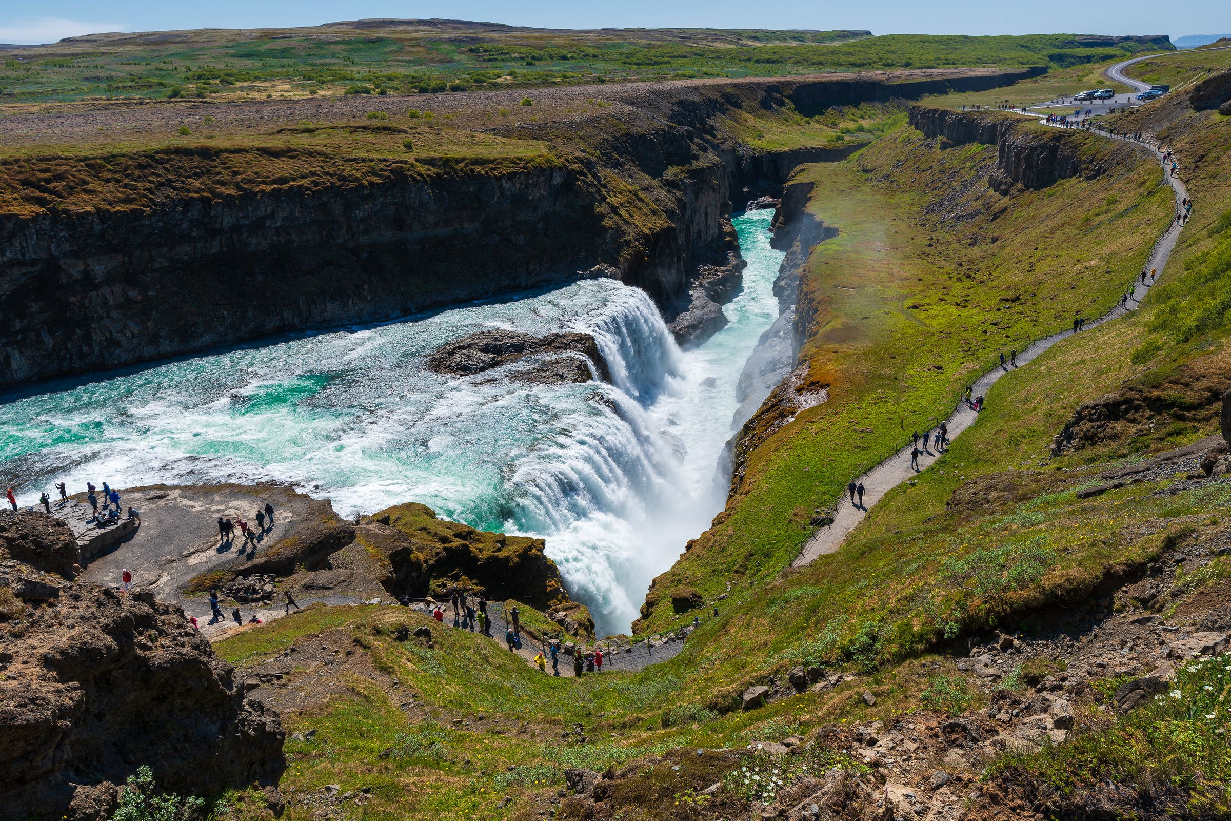
F35 (Kjölur Route) – The Gateway Highland Drive
The F35 offers the most accessible introduction to the F-roads. This 180-kilometer route between Gullfoss waterfall and Blönduós passes through the massive Langjökull and Hofsjökull glaciers, offering stunning views without requiring river crossings.
The highlight is Hveravellir geothermal area, where you can soak in natural hot springs surrounded by steaming vents and colorful mineral deposits. The route also provides access to the Kerlingarfjöll mountains, known for their rhyolite colors and hiking trails.
While F35 has no river crossings, don't underestimate the challenge. The gravel surface has deep corrugations and potholes that can damage suspension if you drive too fast. Plan 4-6 hours for the full crossing, including stops.
F208 (Landmannalaugar Route) – Colorful Mountain Paradise
F208 splits into two sections, northern and southern, each offering different experiences and challenges. Driving the northern section from F26 to Landmannalaugar means no mandatory river crossings, making it accessible to most 4x4 vehicles. You can park at the main area and walk across the footbridges to reach the famous hot springs.
The southern F208 from Kirkjubæjarklaustur is more challenging, with several river crossings that range from ankle-deep to tire-deep, depending on the conditions. In this route, you’ll see otherworldly volcanic landscapes, including views of the Laki crater row and moss-covered lava fields.
Landmannalaugar itself sits in a geothermal valley surrounded by mountains colored in reds, yellows, and greens from rhyolite deposits. The area offers hiking trails, natural hot springs, and camping facilities.

F905 & F910 (Askja Route) – Volcanic Moonscapes
The routes to Askja caldera go through some of Iceland's most alien landscapes. F905 and F910 cross black sand deserts punctuated by colorful volcanic mountains and recent lava flows from the Holuhraun eruption.
Askja caldera contains the dramatic Víti crater, a circular lake formed by a volcanic explosion in 1875. The entire area feels like another planet, with virtually no vegetation and stark volcanic formations that stretch to the horizon.
These routes are only for you if you’re an experienced driver comfortable with multiple river crossings and sandy sections that can trap vehicles. The remoteness means help is far away if things go wrong, so preparing properly is crucial.

F249 (Þórsmörk) – Expert-Level Challenge
F249 to Þórsmörk valley represents the most challenging F-road accessible to non-super-jeep vehicles. The route requires crossing multiple glacial rivers, including the notorious Krossá, which changes depth and course daily.
Many rental companies prohibit F249 entirely, and most visitors choose guided super-jeep tours or scheduled bus services instead. If you do attempt it independently, travel with experienced drivers and accept that you might need to turn back.
Þórsmörk itself rewards the effort 100%, with stunning valley views between Eyjafjallajökull and Mýrdalsjökull glaciers, excellent hiking trails, and mountain huts if you want to stay the night.

Packing Essentials for the F-Roads
Beyond standard travel gear, Highland trips require:
- Extra fuel (gas stations don't exist on F-roads)
- Comprehensive first aid kit
- Vehicle recovery equipment (tow strap, shovel)
- Multiple layers for rapid weather changes
- Non-perishable food for several days
Navigation and Communication
A key thing to do is download offline maps before departing, as cell coverage is unreliable or nonexistent on most F-roads. The 112 Iceland app works offline and can transmit emergency locations via satellite.
Inform someone of your trip and when you plan to return. The environment in the Highlands can change quickly, so being flexible while maintaining basic safety protocols is key.
Rules and Regulations for F-Roads
Off-road driving is strictly illegal throughout Iceland, with some of the world's harshest penalties for violations. The fragile highland ecosystem, including slow-growing moss and volcanic soils, can take decades to recover from tire damage.
Fines for off-road driving start at 100,000 ISK (about $750) per person and can reach 400,000 ISK ($3,000) for serious violations. The Environment Agency of Iceland actively patrols popular areas and uses aerial surveillance to document violations.
Staying on designated tracks protects both the environment and your wallet. F-roads are marked with posts or cairns, and driving outside these marked routes constitutes off-road driving even if you think you're following a "path."
F-Road Access and Seasonal Restrictions
No permits are required to drive open F-roads, but respecting the closure dates is mandatory. Seasonal closures are meant to protect both travelers and the environment during unstable conditions. Attempting closed F-roads can result in:
- Heavy fines for the violation
- Full responsibility for rescue costs
- Potential criminal charges for endangering rescue personnel

Summary
Iceland's F-roads provide access to some of Europe's last remaining wilderness areas, but they require respect, preparation, and the appropriate equipment. These mountain routes aren't for casual sightseeing; they're serious challenges that require 4x4 vehicles, careful planning, and conservative decision-making.